The Food and Agriculture Organization (FAO) of the United Nations projects that by 2050 humanity’s ranks will likely have grown to nearly 10 billion people. Given the limited scope of expanding the arable land, a legitimate question is: where will our food come from? Well, farmers will need to produce more with less while preserving our environment for future generations. And society as a whole has a duty to help them achieve this. Although agriculture is perceived as a fairly traditional economic sector, precision agriculture technologies have already boosted crop yields significantly in the last decades.
What else can be done? What drones have to offer to agriculture? You might argue: UAVs have been around for about a century, so what’s new?
Robust investments in the commercial drone sector have made the technology cheaper, lighter, safer and more sophisticated. Drones can fly on autopilot. Last but not least, there are affordable Near Infrared Cameras on the market. The unique combination of the above-mentioned factors makes possible the commercial utilization of a technology developed by NASA more than 30 years ago.
In an effort to monitor major fluctuations in vegetation and understand how they affect the environment, in the 1980’s scientists began using satellite remote sensors to measure and map the density of green vegetation over the Earth. They observed the distinct colors (wavelengths) of visible and near-infrared sunlight reflected by the plants and applied a vegetation index called Normalized Difference Vegetation Index (NDVI).
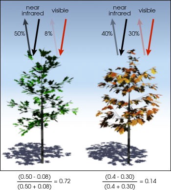
NDVI is calculated from the visible and near-infrared light reflected by vegetation. Healthy vegetation (left) absorbs most of the visible light that hits it, and reflects a large portion of the near-infrared light. Unhealthy or sparse vegetation (right) reflects more visible light and less near-infrared light. The numbers on the figure above are representative of actual values, but real vegetation is much more varied. (Illustration by Robert Simmon). Photo courtesy of NASA T
Today, a drone equipped with a near infrared (NIR) camera becomes the gold standard in crop surveying.
Below are the top 3 practical ways growers can use drones and NDVI cameras to ease their lives, cut costs and improve yields.
1. CROP SCOUT FASTER AND CHEAPER
Crop scouting, also known as field scouting, is the very basic action of traveling through a crop field while making frequent stops for observations. Traditional methods include walking and driving a 4x4 truck or a tractor through the field and observing plants manually.
With the help of an Unmanned Arial Vehicle, farmers can observe hundreds of hectares within hours. On the one hand, they get a better areal picture of the entire field without walking through and damaging the crops. On the other, there is a great return on investment for big farms, as gasoline is eliminated from the equation.
2. DETECT WEEDS, PESTS, FUNGI AND INFESTATION EARLIER
Using a drone mapping software to apply health crop analysis allows to rapidly pinpoint issues on a farm field, such as weeds, pests and fungi.
The earlier you catch the problem, the cheaper to contain it. Once you identify a spot, let’s say the size of a dinner table, you can fix it right away, as opposed to having it spread. This leads to big time and labor savings. And farmers know that some infestations can take the entire farming land in just 2 days.
3. DECREASE INPUTS
NDVI drone maps provide precise data on a granular level. You can see your farm from the sky but also zoom in to few centimeters above the plants. That information allows to make informed decisions. Growers can make targeted nutrient or pesticides applications and generate variable rate prescriptions. And using less chemicals and inputs is not only more efficient from the cost perspective — it also allows to preserve the land for future generations.
Ready to join the drone revolution ?

Mihail Marinov, co-founder at Agrohelper